1. Introduction
Caldera and caldera complexes occur in all environments. On earth, caldera and caldera complexes range in size from <1 km diameter up to 40×75 km, and are formed during the eruption of between 1 and 5000+ km3 of ejecta, mainly of ignimbrite. Larger eruptions are generally less frequent than smaller ones(once every 100 years for 1 to 10 km3 eruptions; once every 100,000 years for >1000 km3 eruptions) (Cole et al., 2004). The eruptions of caldera collapse can be earth shakings, cataclysmic and powerful as many nuclear explosions. They may bring famine, pestilence, tsunamis, plagues, great pyroclastic flows, darkness for many days or month and global climatic disruptions.
Mount Baekdu and six candidates of the caldera in Indonesia have shown the recent volcanic activities and poses threat to the surrounding area. However, Mount Baekdu did likely produce a VEI 7 eruption in about 1000 AD, meaning that any activity at the volcano should be closely monitored. The eruption of Mount Baekdu in the near future predicted in such a high magnitude of eruption and damage could be 10 to 100 times greater than that caused by the 2010 eruption in Iceland. Eruption associated with caldera collapse have led to huge fatalities in Indonesia as well as left global impact, for instances Mount Krakatau erupted in 1883 and Mount Tambora erupted in 1815. Recently, Mount Baekdu in the border of China and North Korea which has caldera lake in its summit claim has shown signs of becoming active and a possible volcanic eruption could devastate the ailing North Korean economy and experts predict that ash from a new eruption would severely damage the Korean Peninsula, China, Japan and Russia; while the 2 billion tons of water in Lake Tianchi would cause severe flood damage, deluge roads and homes within a 30 km radius in hours.
The aim of this work presented in this paper is to obtain Indonesia caldera which resembles to Mount Baekdu for the selection site for future case study in the perspective of similar characteristic, principal hazard, the event of recent volcanic activity and the threat if eruption occurs in the near future. Mount Baekdu and the six candidates of Indonesia caldera were presented in this paper are Mount Krakatau, Mount Tambora, Mount Ijen, Tengger Caldera, Mount Rinjani and Ranau Caldera will be discussed in the following sections.
2. Study Areas
2.1 Mount Baekdu
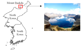
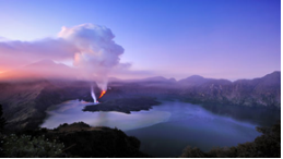
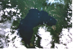
The 2,744 meter high of Mount Baekdu is located on the border between China and North Korea and it is a historically active stratovolcano with 5 km in wide, 850 m in deep summit caldera is filled by scenic Lake Tianchi (Cheonji caldera), as shown in Fig. 1. The 60 km in diameter is dominantly trachytic and rhyolitic volcano (Smithsonian GVP).
It was found that Mount Baekdu has history of eruption more than 10 times since 10 century. The caldera was created by a major explosive eruption took place from Mount Baekdu about 1000 AD with scale 7 in VEI, depositing rhyolitic and trachytic tephra as far away as northern Japan (Smithsonian GVP) and was believed to be about 1000 times that of Mount Eyjafjallajokul in Iceland that erupted in 2010.
2.2 Mount Krakatau
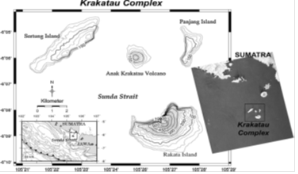
Krakatau is a volcanic island in the Sunda Strait between Java and Sumatra as shown in Fig. 2. It is the most famous and one of the biggest eruption recorded in history, was in 1883 with scale 6 in VEI. The eruption in 1883 produced a series of tsunami which reached up to 40 meters high and smashed into 165 coastal villages in Java and Sumatra caused about 36,000 people perished when those giant waves hit. The explosion was heard to a distance 4,811 km in Rodriguez Island near Mauritius in the Indian Ocean and 3, 224 km away in South Australia. The eruption also caused a large impact on the global climate and temperature dropped as much as 1.2℃ in the succeeding year. Fine particles of dust and aerosols such as sulphur dioxide being transported around the world within two weeks of the eruption.
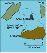
As shown in Fig. 3, this caldera-forming eruption destroyed two thirds of the Krakatau volcanic island in the Sunda Strait and submarine eruption in 1927 produce a new volcano called Anak Krakatau that grown and emerged in the place of the previous of volcano cone. Studies have shown that Anak Krakatau is growing in astonishing speed almost 5 meters per year and erupt frequently.
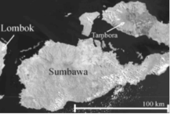
2.3 Mount Tambora
The Tambora volcano on the island of Sumbawa in Indonesia as shown in Fig. 4, sending a massive cloud of aerosols into the stratosphere. It was the largest eruption of the past 500 years (Robock, 2002) erupted in 1815, measures 7 on the VEI scale and emptied about 50~150 cubic km of magma.
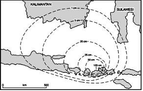
The eruption killed more than 90,000 people in the immediate vicinity (Robock, 2002) and produced global climatic effects known as “A Year Without Summer”, dropped the temperature as much as 3ºC. Caldera collapse destroyed 30 km³ of the mountain and formed 6 km wide and 1250 meters deep caldera. Pyroclastic flows reached the sea on all sides of the peninsula and large tsunami more than 10 meters have occurred. Heavy tephra devastated entire villages, making the site a “Pompeii of Indonesia”. The distant effect of ash fall and the thickness from the eruption were astonishing, as shown in Fig. 5 indicates an approximate 1-100 cm isopach for the phoenix cloud ashfall (Oppenheimer, 2003).
2.4 Mount Ijen
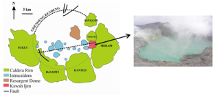
The Ijen volcano complex is a group of stratovolcanoes as shown in Fig. 6 in East Java, Indonesia. It is inside a larger caldera Ijen, which is about 20 km wide. The Ijen crater (Kawah Ijen) is a composite cone of basaltic-andesite to dacitic composition contains the world’s largest lakes of highly acid (pH < 0.5) with approximately 1km, deep 200 meters and mineralised volcanic water about 36 million cubic meters with average temperature 64ºC. Occasional outbursts of phreatic activity, centred within the lake, have formed the main threat in recent times. Apart from potential danger of lahars, it has been known since long that the acid nature of the water also generates environmental problems. Kawah Ijen contains great quantities of dissolved volcanic gases and the green body is the hyperacidic crater lake (Scher, 2012). The gas full of hydrochloric acid and sulphur dioxide and therefore extremely poisonous.
2.5 Tengger Caldera
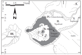
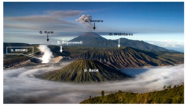
Tengger caldera is located in East Java, Indonesia with 16 km wide sand sea caldera. As shown in Fig. 7, five overlapping clusters of post-caldera cones was constructed on the floor of the sand sea caldera within the past several thousand years. The youngest and most active of these is Mount Bromo having more than 50 eruptions since 1804 and thin solfatara gases always emitted as shown in Fig. 8. Due to the location of Mount Bromo at the base of a steep- walled caldera, it generally only poses a local threat to life during explosive eruptions.
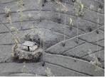
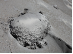
All activity in historic time in the Tengger Caldera has been at Bromo. The latest eruption 2011 was very rich in ash and volcanic bombs as shown in Fig. 9 below.
2.6 Mount Rinjani
Mount Rinjani is an active volcano in Indonesia, administratively located in the Regency of North Lombok, West Nusa Tenggara, as shown in Fig. 10. It rises to 3,726 metres, making it the second highest volcano in Indonesia. On the top of the volcano is a 6×8.5 km caldera, which is filled partially by the crater lake known as Segara Anak (Child of the Sea). This lake is approximately 2,000 metres above sea level and estimated 200 metres deep, also contains hot springs.
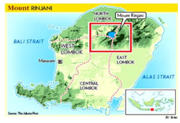
Figure 10
Location of Mount Rinjani in the Regency of North Lombok, West Nusa Tenggara(The Jakarta Post)
The first historical eruption occurred in September 1847. The most recent eruption as shown in Fig. 11 was in May 2009 and the most recent significant eruptions occurred in 1994 to 1995 which resulted in the further development of Gunung Barujari (or ‘New Mountain’ - approximately 2300 metres above sea level) in the center of this caldera and lava flows from the subsequent eruptions have entered the lake.
2.7 Ranau Caldera
Ranau is a large caldera in South Sumatra, 13×8 km Pleistocene caldera partially filled by 300 m deep of Lake Ranau. Lake Ranau is located in Banding Agung District, 125 km from Baturaja. The volcano lies along the Great Sumatran Fault. Mount Seminung is a postcaldera central cone, located on the SE side of the caldera at a height more than 1,600 m above the lake surface. Little is known about the geology of this caldera. On the basis of morphology, the caldera is a simple collapse caldera which southwest and northeast sides are controlled by NW-SE trending regional faults (Verstappen, 1973). The volcano has not been mapped in detail to determine the age of its latest eruption, although fish kills and sulphur smells in late 19th and 20th centuries may be related to sublacustral eruption.
3. Calculation and Discussion
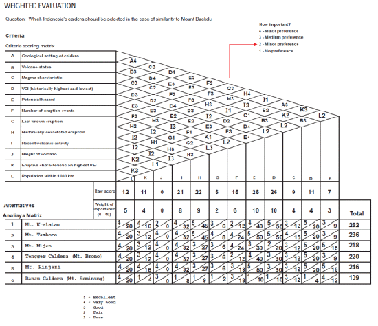
As shown in Table 1, comparison among Mount Baekdu and the six calderas in Indonesia is broken down into twelve criteria. The information in this table will be used to calculate the weighted evaluation as shown in Fig. 13.
Making appropriate decisions to select an Indonesia’s caldera can be a complex process when considering different criteria and all the alternatives available. Evaluating different criteria and alternatives in the engineering field by using matrices is often used to make a decision (Kim, et al., 2007). As shown in Fig. 13, the calculation using weighted evaluation matrix was taken to evaluate a number of alternatives against criteria. The weighted evaluation worksheet is broken down into two parts i.e. the Criteria Scoring Matrix and the Analysis Matrix (Mock, 2003).
First, caldera criteria are considered e.g. geological setting of the caldera, volcano status, magma characteristic, VEI (historically highest and lowest), potential hazard, number of eruptive events, last known eruption, recent volcanic activity, height of volcano, eruptive characteristic on highest VEI and population within 1000 km. Criteria options are weighted against one another to establish the relative importance factor through a scoring process and a numerical score of 1 to 4 is given to the preferred criteria. The sum of each criterion’s score is tabulated into a raw score. The raw score is converted into a weight of the importance factor on a scale of 1 to 10.
Next, the alternatives are listed in the Analysis Matrix e. g. Mount Krakatau, Mount Tambora, Mount Ijen, Tengger Caldera (Mount Bromo), Mount Rinjani, Ranau Caldera (Mount Seminung) are compared to each criterion from the Criteria Scoring Matrix.
By considering all information from Table 1 with the criteria of Mount Baekdu as the basis assessment, a different numerical score 1 to 5 is established for the alternative to criteria comparison. This score is multiplied by the weight of importance factor in order to establish an adjusted subtotal score. The sum of all alternative-to-criteria comparison (adjusted subtotal) scores is tallied to give a final numerical total score that ranks one alternative to another.
According to results of shown in Fig. 13, Mount Tambora reaches 286 scores as the largest final score. The alternative with the largest numerical final total score is the preferred alternative (solution) for the future case study. In addition, the highest VEI of the Mount Baekdu eruption lies between that of Tambora and Krakatau. As also almost volcanoes, there are long periods between huge eruptions, which take time to build up (“plug” process); that in this case Mount Tambora has similarity “plug” process with Mount Baekdu (conversation with Newhall).
Table 1
Calderas comparison(Smithsonian GVP)
4. Conclusion
The work has examined the comparisons among the six calderas in Indonesia which is resembling to Mount Baekdu by using a weighted evaluation matrix for the selection of a site for future case study. Historical eruption associated with caldera collapse led to huge fatalities as well as causing global climatic disruptions. Mount Tambora, the selected site from the six calderas in Indonesia will be taken as future case study with investigation in the perspectives of volcano monitoring, eruption warning to reducing the risk to people, property and saving lives from future volcano activity; collaborate with people and organizations who stand to benefit or lose from the success or failure; identify all potential future scenarios on probable hazards that can be expected to an agreed probability, not just those known from the past.